
This story originally appeared in bioGraphic, an online magazine about nature and sustainability powered by the California Academy of Sciences.
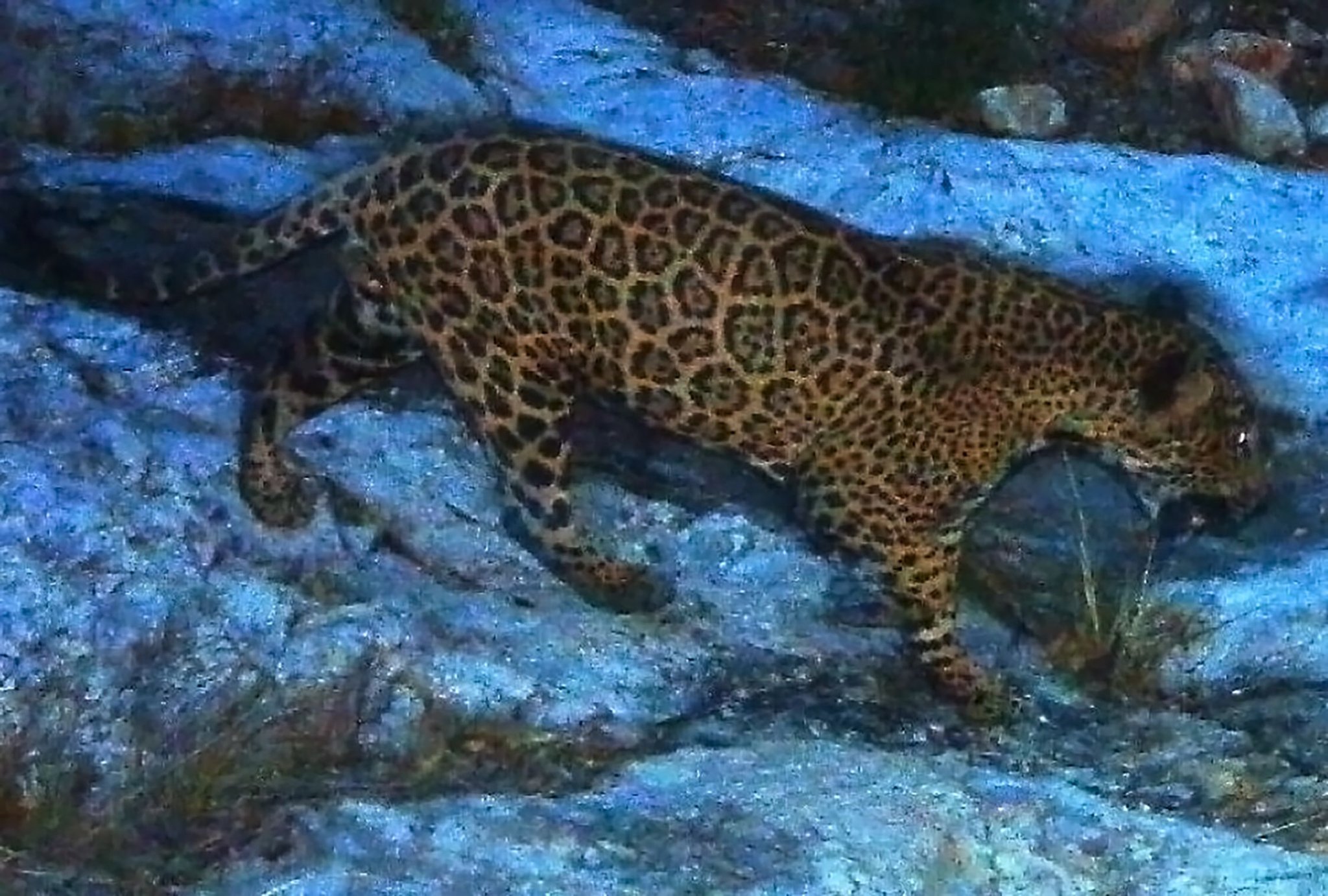
On a quiet, late-spring morning in northern Sonora, Mexico, a beaver putters across a pond the size of a football field. A sinuous dam, 5 feet high, forms the pond’s southern edge. Frogs croak amid gnawed stumps, and the air is alive with birds and flying insects.
“This is all new; this wasn’t here last week,” says Daniel Toyo, an agricultural technician with Naturalia, a Mexican environmental nonprofit. “It takes them three days to build something like this.” Naturalia manages the Rancho Los Fresnos, a 39-square-kilometer (9,577-acre) property that was once a working cattle ranch. Now, it’s a demonstration site for sustainable ranching techniques and conservation education.
Los Fresnos encompasses the largest remaining group of ciénegas, or desert springs, in the watershed of the San Pedro River, which flows north into Arizona and joins the Gila River east of Phoenix. Most of the region’s desert wetlands have been degraded or destroyed by farms, ranches, and urban development.
The beaver (Castor canadensis) stops to nibble on a floating branch. Then it heads for a den dug into the near bank, leaving a wake that spreads across the surface and disappears. The only sound is the breeze rustling the leaves of cottonwood trees, and the occasional bird song.
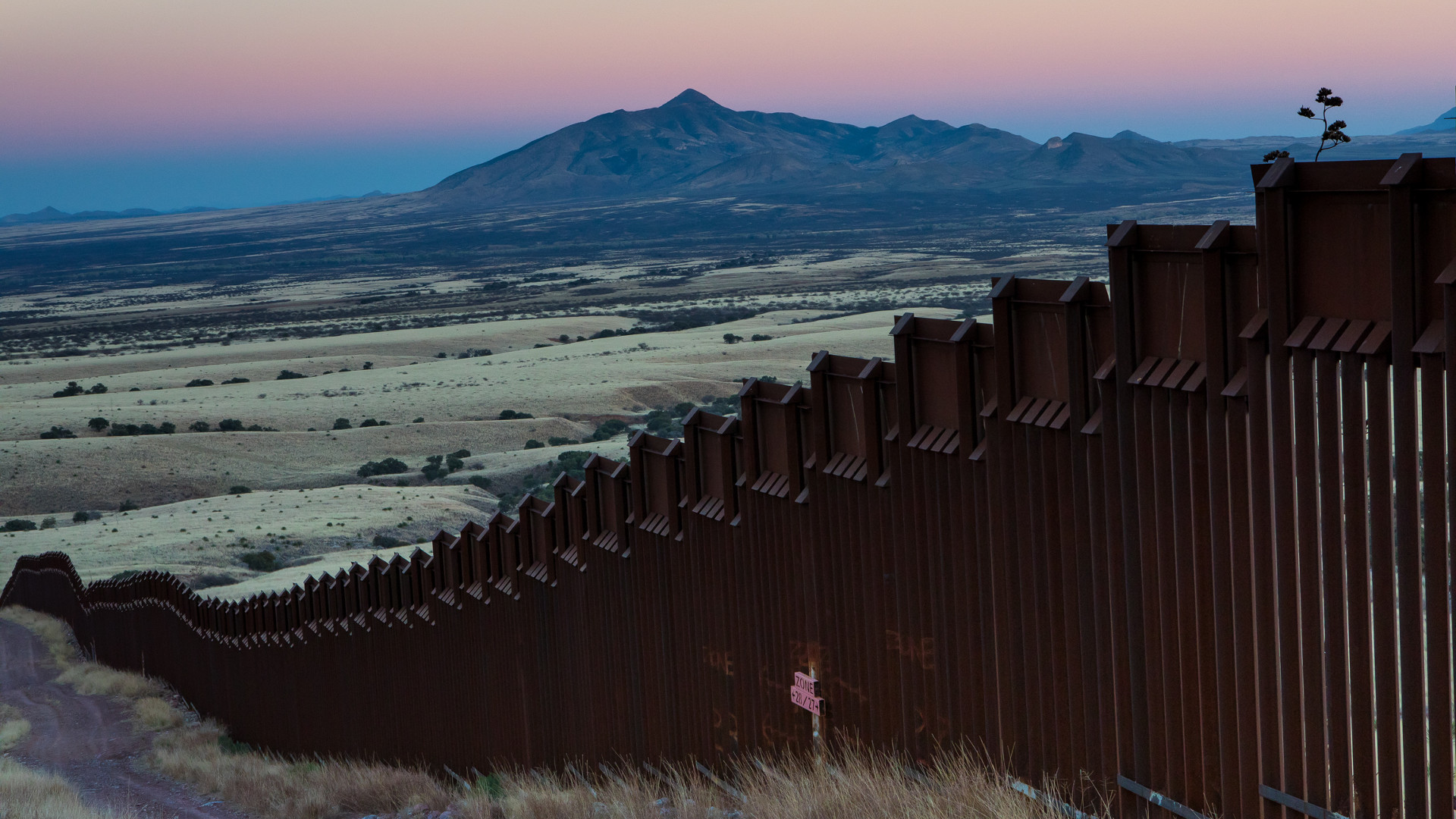
Taking in this placid scene, it’s hard to believe that it could be so close to one of the most controversial international boundaries in the Americas. The Arizona border is just a 5-minute dirt-road drive north.
Gerardo Carreón, Naturalia’s conservation director, walks a short distance upstream and points out rusty cans, socks, and pieces of burlap wedged among the rocks. “Border crossers often leave trash,” he says. “Drug smugglers wrap their feet in burlap sacks to hide their footprints. Sometimes word goes out: ‘Don’t be out on the property after dark.’”
He points out flashes of light in the foothills of the Huachuca Mountains just across the border: the windshields of U.S. Customs and Border Patrol (CBP) trucks glinting in the sunlight. What appears as a tiny white oval hanging high above the vehicles is the CBP’s 200-foot-long helium-filled blimp with a radar system that can detect low-flying, drug-smuggling aircraft from 200 miles away. “I don’t think they’ve ever caught anything,” in part because smugglers have shifted their operations to the ground, Carreón says.
Amid all this, the beavers most likely waddled or paddled south from Arizona, where their forebears were reintroduced in 1999; after all, much of the ranch’s northern boundary is nothing more than a barbed-wire fence. But that would change if President Trump follows through on his campaign promise to build a “big, beautiful wall” between the U.S. and Mexico. Conservationists warn it would wreak havoc on already-stressed ecosystems and organisms along the roughly 3,200-kilometer (nearly 2,000-mile) border. As the president wrangles with Congress over the massive project’s funding, federal officials are already soliciting design bids and bulldozing critical wildlife habitat on public and private lands in preparation.
A study by researchers at the National Autonomous University of Mexico found that 882 vertebrate species, from geckos to pronghorn antelope (Antilocapra americana), would be affected by the new wall, which would slice through wildlife populations and block critical migration routes. The U.S. Fish & Wildlife Service estimates that the wall’s construction could impact 98 endangered species and 108 species of migratory birds.
Even if Trump’s wall is never built, however, existing barriers are already keeping mammals, birds, even reptiles and fish from seeking new territories, finding mates, and following centuries-old paths across the border from the Pacific Ocean to the Gulf of Mexico. Bluster or not, Trump’s pledge is shining a spotlight on a region that already faces serious environmental challenges but has also seen incredible work to resolve them—especially here in the arid, rugged Sky Islands region of southern Arizona and northern Sonora, where people are working to protect the land on both sides of the border, and sometimes across it.
It’s hard to imagine a landscape fragmented in more senses of the word than the Sky Islands. Here, the southern Rockies meet the northern end of Mexico’s Sierra Madre Occidental in a series of isolated mountain ranges surrounded by desert—with the vast Sonoran to the west and the Chihuahuan to the east. The entire eco-region is spread across four states in two countries (Arizona, New Mexico, Sonora and Chihuahua) and divided into a complex mix of protected and unprotected public and private lands.
This collision of mountains and desert has created a place of astonishing ecological richness, with habitats ranging from saguaro-studded plains to spruce-fir forests above 10,000 feet. The Sky Islands is the most biologically diverse part of the U.S.-Mexico border, home to half the bird species in North America during at least part of the year. The Coronado National Forest, which encompasses many of the ranges on the U.S. side, is the most biologically diverse national forest in the country, and also has the highest number of threatened and endangered species, including jaguars (Panthera onca), ocelots (Leopardus pardalis), and Mexican spotted owls (Strix occidentalis lucida).
“People have this idea of the border as a wasteland, a war zone,” says Valer Clark, who manages extensive properties on both sides of the border for the Cuenca de Los Ojos Foundation, a conservation group. “That isn’t the case at all. This is a very rich landscape. It’s a crucial place to preserve.”
But the threat of urban development only increases as the region’s human population grows. In addition, dams, mines, ranches and farms have fragmented and degraded natural habitats throughout the region. As a result, most of its once-extensive wetlands, critical to migratory birds and other native species, are already gone. On top of that, the specter of climate change looms large over the arid region, disrupting rainfall patterns and contributing to more frequent and more intense wildfires. Add in illegal immigration and the booming cross-border drug trade, and you have a place that is as complex politically as it is ecologically.
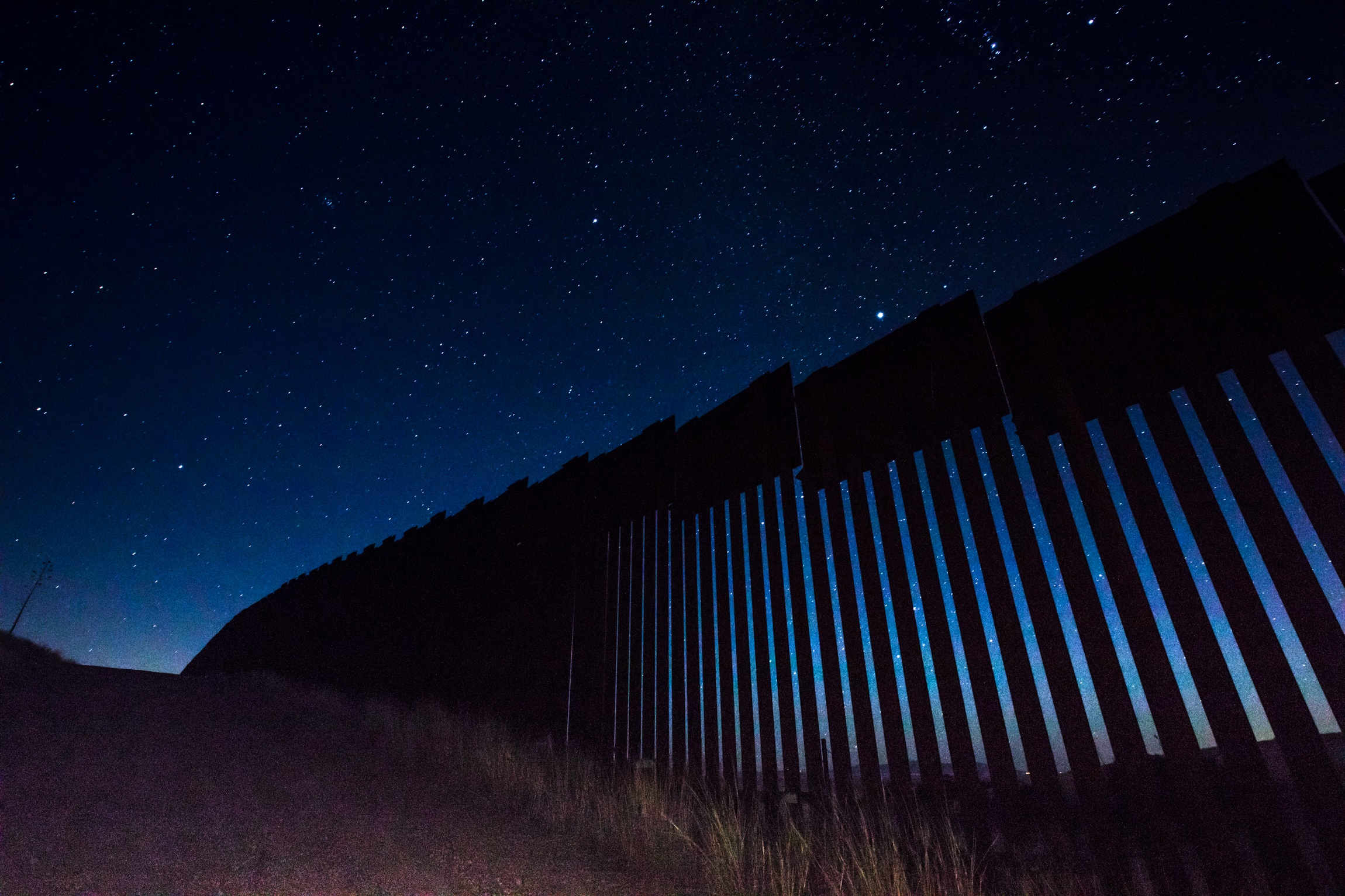
Through the middle of it all, like the thread of a complicated plot, runs the international boundary. About a third of that line is already blocked by some kind of barrier, from barbed-wire fences and tall metal walls to “Normandy fencing” made from steel Xs that look like they’ve been pulled straight off a World War II beach. Most of the barriers are near cities and in places where illegal crossings are most likely to occur. That leaves the more remote, rugged stretches of the border still unfenced—for now.
The environmental impacts of the existing border barriers are mostly unknown, in large part because of how recently and quickly they were built. The Department of Homeland Security waived environmental laws when it put up most of the wall or fencing during a period of “border hardening” in the 2000s. Scientists didn’t have a chance to conduct baseline studies that would allow them to compare the movements of animals, and the overall health of ecosystems, before and after the barriers went up. Construction also included the building of hundreds of miles of access roads, which are known to affect wildlife mobility and cut through populations, especially those of large carnivores and herbivores. A 2014 study on the effects of border infrastructure in four protected areas in Arizona found that barriers curtailed the movement of mammals such as mountain lions (Puma concolor) and coatimundis (Nasua narica)—but had no measurable effect on people trying to cross the border illegally.
The barbed wire fence at the Rancho los Fresnos clearly was not a barrier to beavers. They likely followed the water that flows south from the Huachuca Mountains across the border, which, in a quirk of hydrological irony, merges with the flow from the ranch’s springs and joins the San Pedro River to flow back north into Arizona: two watery border crossings within a handful of miles.
The largest free-flowing river in the southwestern U.S., the San Pedro once teemed with so many beavers it was nicknamed the “Beaver River.” But by 1900, the species had been wiped out by hunters and trappers in search of pelts, and by ranchers and farmers who were frustrated by the animals’ penchant for diverting precious water.
In 1999, the Bureau of Land Management (BLM) began reintroducing beavers in southern Arizona. Improving the landscape was part of the goal: Beaver dams help retain water through the dry season, encouraging the development of riparian areas and the water-dependent plants and wildlife they support. The project was a success, with hundreds of beaver ponds springing up north to the Gila River, and south across the border. The animals first showed up in Los Fresnos after a series of severe storms in 2008, Carreón says. “Everything around here flooded; then we started seeing gnawed tree trunks.” He estimates that three beaver families, each with four to five individuals, live on the property today.
Researchers from the U.S. Geological Survey and the University of Arizona found that the beavers’ environmental engineering has already had a measurable effect along the upper San Pedro. Places where the aquatic rodents colonized, including some sites in Los Fresnos, had a wider variety of birds and more of them, including threatened and endangered species like the Southwestern willow flycatcher (Empidonax traillii extimus). Clearing out large trees and creating ponds and marshes encourages new growth of trees and bushes at the water’s edge, which in turn attract insects and the birds that eat them. This transformation is particularly important along the San Pedro, which is used by more than 300 bird species during their migrations between North and South America. If there had been an impassible wall along the border, of course, the beavers would have stayed in the U.S. and none of this would have been possible.
Another species whose border crossings have been making news lately is the jaguar. The largest cat in the Western Hemisphere once ranged from Patagonia to the Grand Canyon. But by the 1960s, jaguars were largely gone from the U.S., killed by hunters and ranchers protecting livestock. The nearest breeding population was a small one in northern Sonora.
Lone male jaguars were killed by hunters in Arizona in 1971 and 1986. In 1996, a rancher named Warner Glenn was hunting mountain lions in New Mexico’s Peloncillo Mountains when his dogs treed a jaguar instead. He chose to shoot the cat with a camera instead of a rifle—the first time a jaguar had been left alive in the U.S. in decades.
Since then, more have been spotted north of the border, where they have received a decidedly mixed welcome. In 2009 a male jaguar, called “Macho B,” was trapped south of Tucson by a biologist working for the Arizona Game & Fish Department. Estimated to be 16 years old, Macho B was the oldest known wild jaguar, and had been documented on trail cameras crossing the border in both directions for five years.
The animal was sedated, radio-collared and released but eventually had to be recaptured when it became clear something was wrong. Veterinarians found the cat’s kidneys were failing, possibly from the sedative (a drug meant for bears). Eventually Macho B had to be euthanized. The public was outraged and the events became a major scandal, complete with accusations of agency misconduct and criminal prosecutions of whistleblowers.
Two years later another male, dubbed “El Jefe” (The Boss) by local school kids, showed up on trail cameras in the Santa Rita Mountains near Tucson. Wildlife biologist Chris Bugbee studied El Jefe for four years. Bugbee and his wife, Aletris Neils, also a biologist, run Conservation CATalyst, a small nonprofit dedicated to protecting wild cats, out of their home in Tucson.
Bugbee got to know the cat better than anyone. Sometimes El Jefe turned the tables. “I know he followed me,” Bugbee says. “More than once he was the first animal to appear on the camera traps after I left. Once it was only 16 minutes later.” After appearing in hundreds of trail camera images, El Jefe disappeared in late 2015. “He was behaving differently toward the end, staying out in the daylight,” Bugbee says. He thinks the cat probably returned to Mexico to breed.
Biologists like Bugbee and Neils think solo males like El Jefe and Macho B are dispersing north from a population of 125 to 150 animals in northern Sonora, searching for new territories, and possibly mates, at the fringes of their range. (This is one reason the Sky Islands region is so diverse; all these adjoining habitats bring together many species at the edge of their ranges—the biological equivalent of the cantina in Star Wars.) While the increase in sightings is partly because researchers are using more trail cameras, detecting animals they would have missed in the past, Bugbee says, it’s clear that jaguars are starting to push back north across the border. He, Neils, and other experts agree that Trump’s wall would mean the end of jaguars on the U.S. side.
“It’s absolutely essential that the jaguars in northern Mexico be able to expand their range and numbers, to build resilience in the population,” says Randy Serraglio of the Tucson-based Center for Biological Diversity (publisher of The Revelator). “They’re extremely vulnerable because they’re pinned into these small, fragmented areas.” Individuals who push out into new territories can be the most important of all to a species’ survival, he says. “Those are the pioneers who develop new skills, adapt to new habitats.”
Public support is overwhelmingly on the side of bringing the big cats back, Serraglio says. “All of Tucson went nuts when El Jefe became this rock star.” Yet conservationists have found themselves at odds with government agencies and interest groups representing ranchers and farmers, many of whom aren’t thrilled by the idea of bringing back a large predator. After the Macho B debacle, “jaguar recovery is a political nightmare for the U.S. Fish & Wildlife Service,” Serraglio says. The Center has had to sue the agency to get the cats listed under the Endangered Species Act and to declare critical habitat for their survival and recovery as the law requires. The species was listed in 1997.
In March 2014, the Department of the Interior designated 3,092 square kilometers (764,207 acres) of southern Arizona and New Mexico as critical jaguar habitat. In response, the New Mexico Farm and Livestock Bureau and the New Mexico Cattle Growers’ Association filed suit, arguing the decision was “unlawful, arbitrary and capricious.” The key point of contention is whether jaguar habitat north of the border is critical to the species’ recovery. The Fish & Wildlife Service and Arizona Game & Fish Department have both argued that it isn’t, and that jaguar conservation efforts should instead be focused in Mexico.
In December 2016, the Fish & Wildlife Service and a bi-national Jaguar Recovery Team released a 508-page draft recovery plan that lays out a 50-year, $606 million strategy to bring the big cats back in all 19 countries they inhabit. It identifies an area including parts of Arizona, New Mexico and northern Mexico as one of two critical recovery zones—the other stretches from Mexico to Argentina—but doesn’t include reintroducing females into the U.S. Southwest. Neils says the opportunity to breed is critical. “Once we have a female here, I think we’ll have cats permanently.”
The existing border walls probably don’t affect jaguar movement much, Neils says, since they prefer to stick to higher-elevation routes where there currently aren’t any barriers. The irony is that the animals are already beginning to repopulate their historic range in the U.S. on their own, she says, compared to expensive species restoration projects that can drag on for years. “They’re solving the problem for us. We can bring them back for free, just by doing nothing!”
El Jefe himself likely came from a 55,000-acre reserve in northern Sonora owned by the nonprofit Northern Jaguar Project (NJP). In addition to managing the property, the group runs a program called Viviendo con Felinos (Living with Felines), which pays nearby landowners for every animal caught on trail cameras set up on their properties. A jaguar is worth 5,000 pesos, about $275. Other species are worth less, but each can pay off multiple times. In exchange, Viviendo also requires a pledge from participants not to harm wildlife on their properties bordering the reserve.
The program shows how it’s possible to shift landowners’ perspectives on jaguars, says Diana Hadley, NJP president. Ranchers often consider large predators a threat to their herds, but since the program began in 2003, Hadley says, there hasn’t been a single instance of a jaguar killing a cow or calf on any of the properties in Mexico. Meanwhile, the group has assembled what may be the longest continuous database of jaguar sightings, with hundreds of photos of more than 50 different cats. “There’s a waiting list to get into the program,” Hadley says. “The ranchers have been thrilled,” both by the payments and the sense of pride they get from having such a revered creature on their land. At Christmas, each rancher gets a photo book of “his” animals.
On a warm May evening, some of these photos began to appear as huge projected images on the rusty metal posts of the border fence separating Douglas, Arizona from Agua Prieta, Mexico. A 20-foot tall jaguar was replaced by a mountain lion, then an ocelot (Leopardus pardalis) —a smaller spotted cat—and finally a kit fox (Vulpes macrotis) with a bushy tail the size of a Subaru.
A small crowd milled on the American side under the gaze of officers in a Customs and Border Patrol truck idling under a pastel sunset. A similar crowd on the Mexican side was visible through the narrow gaps between the posts. People chatted through the fence as others played music and gave speeches.
Diana Hadley of the NJP, which organized the cross-border event, took the microphone. She explained that the images were all species whose movements are affected in some way by the existing wall. Then she introduced Diego Ezrré, one of 12 Mexican ranchers taking part in the Viviendo program. “The reserve is a great neighbor,” Ezrré said in Spanish. “Because there are more forest animals, we have less depredation by jaguars and pumas.”
“This is the first place we’ve had this exhibit,” Hadley said as stars began appearing overhead. “But I hope we can take it all the way across the border, from California to Texas.”
“To the White House!” called a voice from the crowd.
Some of the jaguars showing up in Arizona almost certainly passed through properties owned by the Cuenca de Los Ojos Foundation (CLO), which manages eleven ranches in the upper watershed of the Yaqui River: two in Arizona’s Chiricahua Mountains and nine in Sonora. The properties range from grasslands to desert to mountain woodlands. Together they harbor more than 25 species listed as threatened or endangered in the U.S.
Driving along Mexico Route 2 in a black pickup with tinted windows, David Hodges, the group’s director of conservation, points out slim white towers jutting from the hills across the border. They’re part of a new remote surveillance network. “Sometimes we see puntos, spotters, on the hills over here,” Hodges says. “They sit in pickup trucks with binoculars and radios, keeping an eye on the Border Patrol for the smugglers.”
The highway has no shoulder and is packed with semis. In the driver’s seat, José Manuel Pérez, CLO’s director of operations for Mexico, sips from a huge sweating soda cup. He turns off the highway at the Rancho San Bernardino, about 15 miles east of Agua Prieta. A desert cottontail bolts up the dirt road ahead of the truck, zigzagging in puffs of dust. The 60-square-kilometer (15,000-acre) ranch was in terrible condition when the foundation bought it in 2000, Hodges says. Previous owners had farmed and ranched it close to death, leaving behind deep arroyos and denuded hills infested with invasive weeds.
The Ciénega San Bernardino used to be the largest wetland in the region, an important stopover for migratory birds that covered thousands of acres. By the 1980s, however, it had shrunk to barely 20 hectares (50 acres).
Hodges rolls up his window as the truck approaches a group of white beehive boxes in the shade of a cottonwood. “They’re a little aggressive this time of year,” he says. The ranch is home to more than 325 species of bees and 240 species of butterflies, the most diverse populations in the world and North America, respectively.
Pérez stops the truck at Silver Creek, a tributary of the San Bernardino River. He walks through a thicket of thorny mesquite bushes to the dry creek bed. A few dozen yards downstream, a 5-foot dropoff cuts sharply across the sand. The ledge is formed by square wire cages, each about the size of a dishwasher and filled with rocks.
Valer Clark, a Manhattan-socialite-turned-conservationist, started buying properties in the Southwest 25 years ago. Through the foundation, she has poured decades of work and millions of dollars into bringing 607 square kilometers (150,000 acres) of damaged lands back to life, replanting native grasses and reintroducing native fish, deer and turkeys. But all this life needs water, so restoring natural flows has been a top priority.
The wire cages, called gabions in Spanish, are a low-tech and relatively inexpensive way to alter the flow of water without blocking it completely, Hodges explains. In the desert, soils laid bare by grazing and agriculture are washed away by summer monsoons. Precious water rushes through deep, narrow gullies without much soaking into the ground. Building ledges and berms out of gabions slows down the flow. Water lingers, meanders, and deposits sediment that fills in and widens the streambeds. With enough work and maintenance, eventually the streams start to look like what they used to be before human activity changed the landscape.
Clark and her employees have built thousands of gabions and small rock dams, called trincheras, on the foundation’s properties. Together with replanted vegetation like willows and cottonwoods, they have brought overgrazed and drought-stricken streams like this one back to life. “This has filled in twelve feet since Val started restoration work,” Hodges says.
Clark lives on El Coronado ranch, one of the properties in the Chiricahuas. After years of flow restoration, “now the mountains are weeping water after the rainy season,” she says. The hills are covered with grass again, and Coues deer, black bears, and Gould’s turkeys roam.
“This is a token effort,” Clark admits. “We’ve made one creek up here run.” But the water table at San Bernardino has risen 30 feet in the past eight years, compared to other places nearby where it has fallen hundreds of feet. The wetlands have expanded, and bird and mammal populations are rising.
A few hundred yards up the streambed, a vehicle barrier marks the international boundary. (San Bernardino has 35 miles of border forming its northern edge.) Illegal border crossings have slowed dramatically here in recent years, Hodges says, because of increased security as well as the improving Mexican economy. “Jobs that used to pay 10 times as much in the U.S. now only pay three times as much,” he says. “The wall never worked anyhow—it was basically a speed bump.”
On the opposite side of the fence is the San Bernardino National Wildlife Refuge, whose main objective is protecting threatened desert fish like the Yaqui chub (Gila purpurea) and the Yaqui beautiful shiner (Cyprinella formosa). Though it’s only a few steps away from where we stand, to get from there to the ranch legally requires driving west on Geromino Trail to Douglas, passing through the checkpoint to Agua Prieta, and then back east on Route 2. On a good day, it takes an hour.
The existing border wall is already a major impediment to international conservation efforts, says refuge manager Bill Radke. Regulations have tightened and cross-border travel is more difficult for government employees. “There was a time when you could just walk across the border and measure stuff, but times have changed,” he says. “Now what would have taken an hour takes a day.” Nonetheless, “if you’re suddenly faced with a landscape that’s being divided, barricaded, fragmented, it does force you to think of options and partners you might not have thought of.”
The refuge has coordinated with CLO to share data on erosion control, ground water levels, and fish and bird populations. When the refuge had to thin out cottonwoods and willows for security reasons, they dug them up and handed them across the fence to workers at San Bernardino, where there were replanted. Some they simply tossed in the river and let them float across.
This fall, CLO will launch the Great Southwest Corridor initiative, to ensure that cross-border wildlife routes in the Sky Islands region remain intact and functioning. While the program predates Trump’s wall plans, according to CLO’s Hodges, it is a response to “longer-term political uncertainty” related to how the border is secured. Potential partners include conservation groups like The Nature Conservancy, the Sierra Club, and Defenders of Wildlife, as well as private U.S. landowners and Native American tribes.
“We’re at a very important point right now,” says Gerardo Carreón of Naturalia, another CLO partner. “People on both sides of the border are coming together and saying, ‘We have to do something.’”
Nonetheless, back in March the Department of Homeland Security started soliciting design prototypes that were both “aesthetically pleasing” and “physically imposing.” (The president himself has suggested the wall could be transparent and/or covered with solar panels. He has also backed away from his initial promise of a nearly 2,000-mile-long wall, suggesting it might be just 700 miles long.)
In Texas, New Mexico, and California, the U.S. Army Corps of Engineers has begun drilling and collecting soil samples in preparation for construction. Engineers hired by the Customs and Border Patrol have begun surveying and clearing land for a new wall and two parallel access roads in the Rio Grande Valley of south Texas. Some of the surveys have crossed private land and important wildlife refuges, prompting protests.
Paying for the wall is still very much under debate. In July, the House Appropriations Committee approved spending bills that include $1.6 billion to construct additional wall and fencing along 74 miles of the border. But Senate Democrats have promised to block the funding, and so far, Mexico’s president Enrique Peña Nieto has flatly refused Trump’s request to pay for any part of it. At a rally in August, Trump threatened to shut down the U.S. government if necessary to secure the funding.
In the meantime, animals keep finding their way across. In March, a female Mexican gray wolf was photographed near Chiricahua National Monument in southeast Arizona. It was the first documented wolf from Mexico since reintroduction efforts began there more than two decades ago, Hodges says, and the wolf, like the jaguars, came from and crossed the border on Cuence de los Ojos lands.
And late last year, two new jaguars also showed up in southern Arizona. One was on the Fort Huachuca military reservation near Sierra Vista. Students on the nearby Pascua Yaqui Reservation named it “Yo’oko Nashuareo,” the Yaqui word for jaguar. The other was spotted in the Dos Cabezas Mountains near Wilcox, almost 100 miles north of the border, the farthest north a jaguar has appeared in decades.
Previously in The Revelator: