
In 2016 California’s rainy season kicked off right on schedule, at the beginning of October. The rains came — and then just kept on coming. By February there was so much water filling Northern California’s rivers that Oroville Dam, the tallest in the country, threatened to break after its spillway and emergency spillways both failed.
Water managers averted a crisis at the dam, but not before 180,000 people living downstream were evacuated.
It was a wake-up call. In just a few months California had gone from five-year-drought to deluge, ending up with the second wettest year on record for the state. It served as a warning of things to come. With rising temperatures from climate change and an increase in the number of extreme storms predicted, scientists have warned of “climate whiplash” — more pronounced swings between wet and dry that could make floods even more dangerous and costly.
It’s an issue that’s top of mind not just in California, but across the country. The United States just endured the wettest 12 months on record, and flooding this spring resulted in federal disaster declarations in Iowa, Kansas and Nebraska. Dozens of other states and counties declared emergencies, and at the time of this writing, floods had already claimed 67 lives nationwide. They’ve also caused billions of dollars in property damage and swamped farmers have experienced billions more in economic losses.
In all of these cases, we see a common thread: It’s not just the direct blows from nature that are the problem. We’ve made things worse by paving over floodplains, channelizing rivers, and draining wetlands.
But change could be on the horizon. Today more and more communities are beginning to realize that 20th century development practices are harmful. It’s ushering in a new era of thinking about floodplain management — one that involves letting rivers behave like rivers.
Making Room for the River
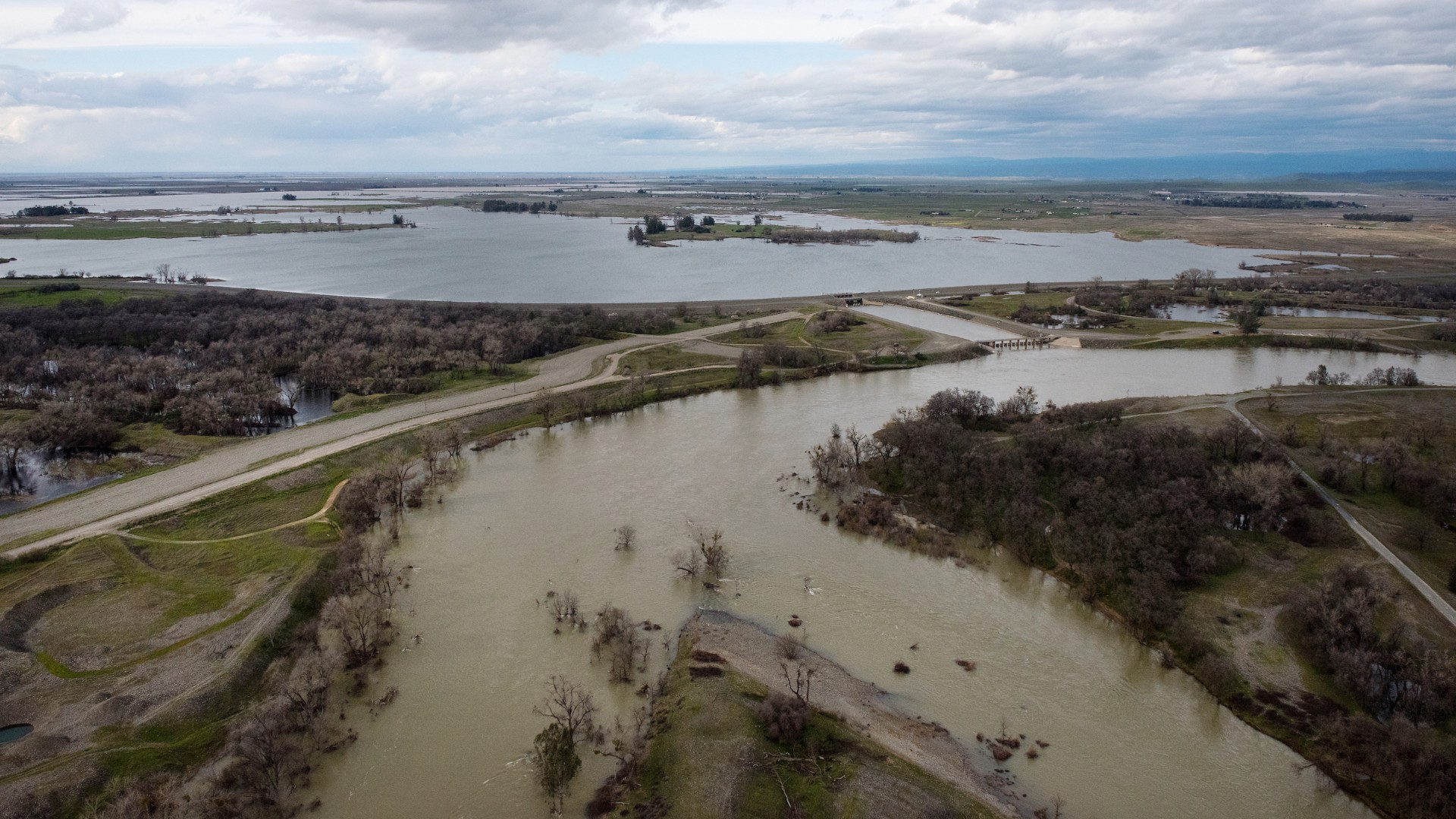
In February 2017, when managers released water out of Lake Oroville to prevent the dam from failing, it went raging down the Feather River, a tributary of the Sacramento River. Another disaster could have occurred downstream where the Feather River’s channel narrows and the levee has failed before.
But the Three Rivers Levee Improvement Authority completed a project in 2010 to set the levee back along six miles of this dangerous stretch of river, which gave more room for high flows to pass through without the risk of levee damage or failure, while also creating 1,500 more acres of riparian habitat.
That plan paid off. “After that huge Oroville dam incident, this area and this new levee were just unscathed by the big flood,” says John Cain, director of conservation for California flood management at the nonprofit American Rivers. “So by setting back the levees, you create room for the river, decrease the flood risk and decrease wear and tear on the system to ensure the levee system’s integrity.”
This idea of setting back levees is one part of the implementation of the Central Valley Flood Protection Plan, first adopted in 2012 and updated in 2017. The plan, Cain says, is groundbreaking in several ways.
The first is that it’s not a flood-control plan, it’s a flood-risk management plan — and the difference on the ground is much more than semantics.
“When you think about the challenge of managing the risk associated with flooding as opposed to trying to control floods, it dramatically changes the tools you use,” says Cain. “Flood control is really a fool’s errand, particularly in an era of climate change. Flooding is going to happen. The question is, how do we manage it so we limit the consequences for property and people?”
Previous flood plans have been mostly about building infrastructure — levees, dams and flood walls, he says. This new plan still allows for strengthening levees in some places, such as around the cities of Sacramento and Stockton, but there’s also more focus on restoring floodplains and setting levees further back from the river.
That’s not always as easy as it sounds when much of the area you want to allow to flood already contains housing developments, shopping malls or prime agricultural land.
“Private landowners can be reluctant, so coming up with some incentive package is a hurdle,” says Cain. “You’ve got to find the funding and the political will to do that. That’s a very big challenge.”
The plan also prioritizes projects with multiple benefits. So instead of funding efforts that are just about controlling extreme flood events, the plan helps to develop projects that provide a variety of additional outcomes, such as groundwater recharge, open space and recreation opportunities, and clean water amenities and wildlife habitat.
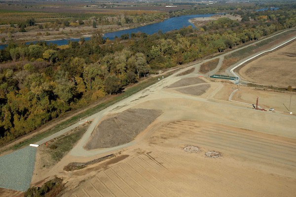
One project in West Sacramento about a mile from the state capitol moved the levee back 200 to 800 feet along a six-mile stretch of the Sacramento River. It’s an area that gets walloped by water in the winter, and now this added levee width decreases the flood risk and creates crucial habitat for endangered salmon that migrate down the river. It also provides habitat for waterfowl and other wildlife.
Tools for a Climate Change Century
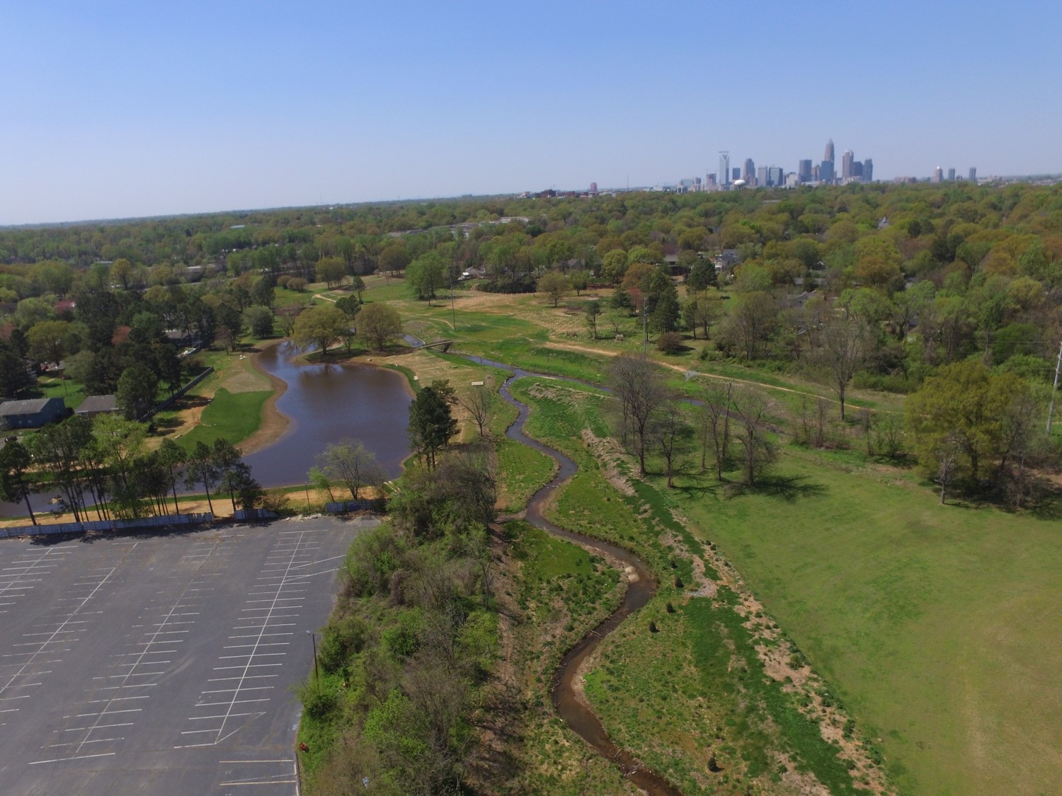
On the other side of the country, residents of Mecklenburg County, North Carolina, home to the growing city of Charlotte, know a thing or two about flooding. The area got engulfed in 1995 and then again in 1997. Some residents hadn’t finished paying for the furniture and cars they’d lost in the first flood before the second one washed them out again, remembers Dave Canaan, the county’s storm water services director.
And worse, some of the flooding in 1997 wasn’t even in the areas that county officials thought would flood, based on their Federal Emergency Management Agency maps.
Locals weren’t happy, and that spurred the county to re-evaluate its strategy.
“We decided, let’s have a policy where floodplains are meant to flood,” says Canaan.
It seems like a simple idea, but it’s actually groundbreaking in practice and is already offering a brighter future for flood resilience.
“We thought, maybe we’re not doing this as best as we can, maybe we need to take the playbook and throw it out and come up with a whole new playbook on how we’re managing our floodplains,” says Canaan.
By 1999 the board of commissioners had adopted a new floodplain-guidance document. That’s meant big changes for the county.
For one thing, residents now receive better communication about their floodplain risk, including a new notification system to warn homeowners and businesses ahead of a storm, says Canaan.
The county also made a major policy change: It stopped relying on FEMA’s floodplain maps because they weren’t updated frequently enough and didn’t take into account how future land use would affect floods.
When Canaan and his colleagues designed new maps that took into account future development conditions, they projected the community’s flood line would increase dramatically compared to their out-of-date FEMA maps from 1985. “We realized we could literally be permitting a single-family residence that within 10-20 years could have four feet of water,” he says.
So when they rolled out their new maps that showed more homes in the floodplain, they also began a buyout program. Over the past 19 years it’s moved 700 families and 450 buildings from the floodplain. That’s reduced liability in the community and it’s also provided a public benefit — they’ve turned that cleared land into 180 acres of new open-space greenway.“It’s really a quality of life investment that we’re making,” he says.
Since the buyout program started, they’ve spent a combined $60 million in federal, state and local money and have avoided $25 million in losses so far — a number that will grow with each passing storm.
The program is now 100 percent locally funded, and the county keeps cash on hand to use for buyouts so it can step in immediately after a flood and make an offer, instead of waiting several years for federal funding post-disaster. There’s also a retrofit program that helps homeowners stay in homes by making improvements to limit the possible flood damage. Typically homeowners chip in 25 percent of the cost, and the county’s stormwater utility pays the rest, says Canaan. The program has also helped homeowners significantly reduce their flood insurance rates.
In 2012 the county launched a comprehensive tool to help it evaluate risk and determine which areas should be prioritized for taking out of the floodplain. The tool looks at much more than the cost to rebuild a flood-damaged home; it also takes into consideration things like the cost of putting a swift-water rescue team in harm’s way and the benefit of having public land to use for recreation or to build features that will filter pollutants and improve water quality.
“We run the risk scores and that score translates into what the mitigation option ought to be,” says Canaan. Participation by homeowners is totally voluntary, he adds, and the county doesn’t condemn any properties.
He says they’re working now with the Department of Homeland Security to update and improve the tool so it can be of use to other communities. Different regions will have vastly different factors to asses, but he says the methodology that Mecklenburg County used in its approach to floodplain management can be applied anywhere.
Common tools are one thing, but the most crucial part of the development of the new plan actually came from the input of local groups and experts. “Public engagement helps to make sure we keep things in perspective,” he says.
And in the face of unknown risks from climate change, stakeholder groups have also helped county staff add an extra layer of precaution to their risk assessment and planning.
“The more and more I see of more frequent events — not just rainfall, but droughts — I think we need to say we don’t know as much as we think we know and therefore we’re going to put in additional safety factor on top of what we just calculated,” says Canaan.
New thinking about floodplain management allows us to re-evaluate how we determine risk — something that’s crucial today, says American Rivers’ Cain.
“Risk is really the probability of flooding multiplied by the consequences of flooding,” he says. “And what we tried to do in the 20th century was control the probability of flooding. That was generally not a winning strategy and it’s definitely a losing strategy as the climate changes.”
![]()